Unlocking East Java’s Secrets: Why Two Neighboring Volcanoes Erupt So Differently
Unlocking East Java’s Secrets: Why Two Neighboring Volcanoes Erupt So Differently
Link to the original paper: https://www.sciencedirect.com/science/article/abs/pii/S037702732500191X
Author of the original paper: Ibrahim etal. (2025)
Rewritten for FITB blogpost by: Mirzam Abdurrachman and Dasapta Erwin Irawan
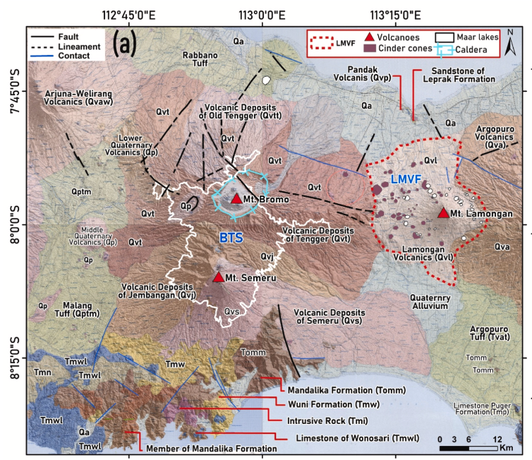
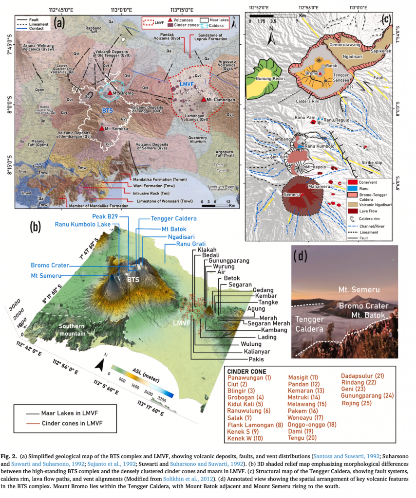
East Java, Indonesia, is home to some of the world’s most dynamic volcanoes. But if you travel just 40 to 50 kilometers between two major volcanic areas—the Bromo–Tengger–Semeru (BTS) complex and the Lamongan Volcanic Field (LMVF)—you witness dramatically different behaviors.
On one side, you have the mighty BTS complex, featuring Semeru, Java’s most persistently active volcano, known for frequent, large-scale eruptions that can last for months or years. On the other side is the LMVF, a broad area covered by dozens of small cinder cones and maar lakes (craters formed by explosive contact between magma and water). LMVF has been mostly quiet since 1898.
Why do these two close neighbors act so differently? A recent study used specialized geophysical tools to map the underground plumbing systems, confirming that their behavior is dictated by opposing tectonic forces acting deep within the Earth.
Peering Beneath the Surface
To understand what feeds these volcanoes, scientists used an integrated approach combining gravity and magnetic data—essentially taking underground “X-rays” of the Earth’s crust down to 20 km depth. This technique allowed them to map the location, size, and connectivity of dense rock bodies, which often indicate cooled or stored magma.
The research team, which included Khalil Ibrahim, Satria Bijaksana, Mirzam Abdurrachman (Petrology, Volcanology and Geochemistry Research Group), and colleagues from institutions like the Institut Teknologi Bandung (ITB), Universitas Negeri Malang, and Universitas Udayana, found two radically distinct models for magma storage.
BTS: The Deep, Connected Magma Tank
Beneath the constantly active BTS complex, the data revealed a large, vertically extensive, high-density body—like a massive, continuous underground magma reservoir or intrusive complex. This magma storage system extends deep, from about 5 km down to 20 km depth, with evidence that the reservoirs beneath Semeru and Bromo are laterally connected.
This deep, connected system explains BTS’s continuous activity. The magma is held deep because the BTS region is subjected to N–S compressional stress (the Earth is squeezing the area). This compression promotes the storage and transfer of magma at depth, ensuring a persistent, long-term supply for large eruptions.
LMVF: The Shallow, Fractured Pathways
The Lamongan Volcanic Field tells a completely different story. The geophysical maps showed no evidence of a centralized, deep magma reservoir beneath LMVF. Instead, magma only appears as shallow, discontinuous, dyke-like intrusions—thin, vertical pathways—at depths of less than 2.5 km.
In LMVF, the region is under extensional stress (the Earth is pulling apart). This extension causes fractures (faults). Magma ascending from the mantle exploits these pre-existing NW–SE and NE–SW fracture systems, rising quickly in small, isolated volumes, leading to single, short-lived eruptions (monogenetic activity) that create the many scattered cones and maars.
Critical Insights for Regional Policy and Safety
This deep-diving research offers immediate practical benefits for local policy makers and emergency planning in East Java by enabling differentiated volcanic hazard assessment.
-
BTS Planning: Because BTS is sustained by a vertically extensive, laterally connected deep reservoir, policy makers must prioritize continuous, high-intensity monitoring and long-term preparedness for persistent, large-scale explosive and effusive activity, consistent with Semeru’s history.
-
LMVF Planning: Since LMVF lacks a deep magma tank and is controlled by shallow faults, the hazard is different. Future activity would likely involve small, localized eruptions forming new maars or cinder cones. Policy makers must focus resources on planning for the primary LMVF challenge: the unpredictable location of a new vent along the established NW–SE and NE–SW fracture systems.
By understanding that these adjacent systems are controlled by fundamentally different tectonic forces—compressional squeezing creating deep reservoirs at BTS, versus extensional pulling creating shallow fractures at LMVF—policy makers can tailor monitoring efforts and land-use planning accurately, optimizing the allocation of resources.
Hits: 13

No Comments