
Java is Sinking: A Silent Crisis Beneath Our Feet
Author: Teguh Purnama Sidiq and Irwan Gumilar
Editor: Dasapta Erwin Irawan
Sumber: Sidiq, T.P.; Gumilar, I.; Abidin, H.Z.; Meilano, I.; Purwarianti, A.; Lestari, R. Spatial Distribution and Monitoring of Land Subsidence Using Sentinel-1 SAR Data in Java, Indonesia. Appl. Sci. 2025, 15, 3732. https://doi.org/10.3390/app15073732
A recent study using advanced satellite technology has revealed a worrying reality: Java Island, home to more than 150 million people and the economic heart of Indonesia, is experiencing significant land subsidence at an alarming rate. This silent phenomenon, suspected to be caused in part by excessive groundwater extraction, poses serious threats to urban areas, infrastructure, and the environment across the island.
For over two decades, land subsidence has been a known issue in Java, particularly in major cities. However, previous studies often focused on individual areas, overlooking the broader picture. This new research, published in Applied Sciences, leverages Sentinel-1 Synthetic Aperture Radar (SAR) data from 2017 to 2023 to provide a comprehensive map of land subsidence across the entire island. The study was authored by a collaboration of researchers from Institut Teknologi Bandung, Faculty of Earth Science and Technology and School of Electrical Engineering and Informatics, Teguh P. Sidiq, Irwan Gumilar, Hasanuddin Z. Abidin, Irwan Meilano, Rahayu Lestari, along with Ayu Purwarianti.
Key Findings: A Widespread Problem
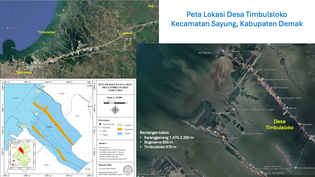
The study identified ten regions with noticeable land subsidence, impacting nearly 60 million residents. Among these areas are Serang, Greater Jakarta (including Tangerang, Jakarta, and Bekasi), Cianjur, Bandung, Cirebon, Brebes and Tegal, Pekalongan, Greater Semarang (including Kendal, Semarang, and Demak), Surabaya, and Sidoarjo. The highest rates of subsidence were observed in Bandung, reaching up to 200 mm/year, while Greater Jakarta experienced rates of up to 150 mm/year, with Bekasi reaching 150 mm/year, Jakarta 110 mm/year, and Tangerang 80 mm/year. Greater Semarang saw subsidence up to 160 mm/year, and Pekalongan up to 110 mm/year. Other areas such as Serang, Cianjur, Cirebon, Brebes, Tegal, Surabaya, and Sidoarjo experienced rates ranging from 60 to 140 mm/year. Notably, Cianjur and Brebes, which were previously unmentioned in land subsidence studies, showed rates of approximately 80 mm/year and 70 mm/year, respectively.
The research indicates a strong correlation between land subsidence and urban and industrial zones, suggesting that anthropogenic activities, particularly the overexploitation of groundwater for residential and industrial needs, are primary drivers.

Impacts and the Way Forward
The consequences of land subsidence are severe and far-reaching, leading to damage to crucial infrastructure, increased frequency and severity of flooding, and reduced groundwater capacity. In Greater Jakarta, for instance, buildings have already sunk, and ground levels in Bekasi are now lower than the surrounding water. In Serang City, subsidence up to 60 mm/year is suspected to be caused by excessive groundwater use in residential areas. Similarly, in Bandung, the highest subsidence rates are in residential areas where residents extract groundwater for daily use from depths of 60-80 meters.
This comprehensive mapping of land subsidence in Java is a vital step for urban planning and environmental management. It highlights the urgent need for continuous monitoring and effective mitigation strategies to prevent further land degradation and protect communities from the escalating hazards.
Hits: 7


No Comments